
 According to the report, the long-term indicators of climate change such as increasing carbon dioxide concentrations, rise of sea-level and ocean acidification continue unabated.
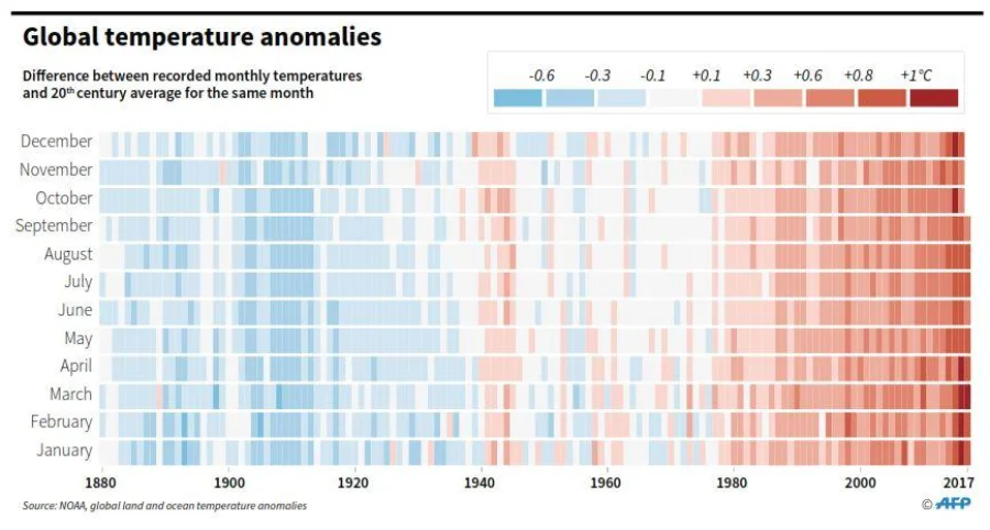
The global mean temperature in January-September 2017 was warmer than the 1981-2010 average, the report said.
The Arctic Sea ice coverage remains below average, and the previously stable Antarctic Sea ice coverage is near a record low.
The WMO report is based on information collected by different UN agencies on human, socio-economic and environmental impacts, aimed at providing a more comprehensive policy brief for decision makers on the interplay between weather, climate and water and the UN global goals at the conference.
It says this year’s extreme events have affected the food security of millions of people, especially the most vulnerable.
A review of UN’s Food and Agriculture Organisation found that, in developing countries, agriculture accounted for 26% of all the damage and loss associated with medium to large-scale storms, floods and drought.
In case of rainfall, the Indian Subcontinent, including Bangladesh, has experienced 5% below average rainfall for the 2017 monsoon season – June to September – but above-average rainfall in the northeast and adjacent countries led to significant flooding, the report says.
Many parts of the Indian Subcontinent were affected by monsoonal flooding, despite overall seasonal rainfall being near average.
Terming the flood in Bangladesh “most serious”, the WMO report also said the Rangpur district in the country’s northeast region experienced a month’s worth of rain – 360mm – in just two days – on August 11-12.
Referring the World Health Organisation’s findings, the WMO report states that more than 13,000 cases of waterborne diseases and respiratory infections were reported during three weeks in August in Bangladesh because of the flood caused by erratic and heavy rainfall.
This year is likely to be one of the three hottest years on record, with many high-impact events across the world, including catastrophic hurricanes, floods, devastating heat waves and drought.
The average global temperature in the period of January-September 2017 was approximately 1.1°C above the pre-industrial era, according to a World Meteorological Organisation report issued on Monday, on the inaugural day of Conference of the Parties 23 (COP23), the annual UN climate conference taking place in Bonn, Germany.
Petteri Taalas, secretary general of the WMO, said 2015, 2016 and 2017 were the top three years in terms of temperature records.
“This is a part of a long-term warming trend,” he said.
“We have witnessed extraordinary weather, including temperatures topping 50 degrees Celsius in Asia, record-breaking hurricanes in rapid succession in the Caribbean and Atlantic reaching as far as Ireland, devastating monsoon flooding in South Asia and others affecting many millions of people and a relentless drought in East Africa,” he further said.
Patricia Espinosa, executive secretary of UN Framework Convention on Climate Change, the UN agency that is hosting the Bonn conference, said: “These findings underline the rising risks to people, economies and the very fabric of life on Earth if we fail to get on track with the aims and ambitions of the Paris Agreement.”
“The truth is undeniable. Our climate is getting hotter every year and the message is that climate action is needed now, not later,” said Jennifer Morgan, executive director of Greenpeace International. “We have no time to waste. These numbers again expose the dire threat to people on the front line of climate change. This must and will change.” According to the report, the long-term indicators of climate change such as increasing carbon dioxide concentrations, rise of sea-level and ocean acidification continue unabated.
The global mean temperature in January-September 2017 was warmer than the 1981-2010 average, the report said.
The Arctic Sea ice coverage remains below average, and the previously stable Antarctic Sea ice coverage is near a record low.
The WMO report is based on information collected by different UN agencies on human, socio-economic and environmental impacts, aimed at providing a more comprehensive policy brief for decision makers on the interplay between weather, climate and water and the UN global goals at the conference.
It says this year’s extreme events have affected the food security of millions of people, especially the most vulnerable.
A review of UN’s Food and Agriculture Organisation found that, in developing countries, agriculture accounted for 26% of all the damage and loss associated with medium to large-scale storms, floods and drought.
In case of rainfall, the Indian Subcontinent, including Bangladesh, has experienced 5% below average rainfall for the 2017 monsoon season – June to September – but above-average rainfall in the northeast and adjacent countries led to significant flooding, the report says.
Many parts of the Indian Subcontinent were affected by monsoonal flooding, despite overall seasonal rainfall being near average.
Terming the flood in Bangladesh “most serious”, the WMO report also said the Rangpur district in the country’s northeast region experienced a month’s worth of rain – 360mm – in just two days – on August 11-12.
Referring the World Health Organisation’s findings, the WMO report states that more than 13,000 cases of waterborne diseases and respiratory infections were reported during three weeks in August in Bangladesh because of the flood caused by erratic and heavy rainfall.
According to the report, the long-term indicators of climate change such as increasing carbon dioxide concentrations, rise of sea-level and ocean acidification continue unabated.
The global mean temperature in January-September 2017 was warmer than the 1981-2010 average, the report said.
The Arctic Sea ice coverage remains below average, and the previously stable Antarctic Sea ice coverage is near a record low.
The WMO report is based on information collected by different UN agencies on human, socio-economic and environmental impacts, aimed at providing a more comprehensive policy brief for decision makers on the interplay between weather, climate and water and the UN global goals at the conference.
It says this year’s extreme events have affected the food security of millions of people, especially the most vulnerable.
A review of UN’s Food and Agriculture Organisation found that, in developing countries, agriculture accounted for 26% of all the damage and loss associated with medium to large-scale storms, floods and drought.
In case of rainfall, the Indian Subcontinent, including Bangladesh, has experienced 5% below average rainfall for the 2017 monsoon season – June to September – but above-average rainfall in the northeast and adjacent countries led to significant flooding, the report says.
Many parts of the Indian Subcontinent were affected by monsoonal flooding, despite overall seasonal rainfall being near average.
Terming the flood in Bangladesh “most serious”, the WMO report also said the Rangpur district in the country’s northeast region experienced a month’s worth of rain – 360mm – in just two days – on August 11-12.
Referring the World Health Organisation’s findings, the WMO report states that more than 13,000 cases of waterborne diseases and respiratory infections were reported during three weeks in August in Bangladesh because of the flood caused by erratic and heavy rainfall.